Read Report Online: Part 1
Read Report Online: Part 2
Executive Summary
Determining Abundance and Distribution of Eelgrass (Zostera spp.) in Tillamook Bay Estuary, Oregon Using Multispectral Airborne Imaging
Seagrass beds have long been recognized as critically important components of estuarine ecosystems and are declining worldwide. In the Pacific Northwest, eelgrass (Zostera spp.) beds may be adversely effected by human impacts from agriculture, forestry, oyster culturing and shellfish harvesting (see Phillips, 1984 and Wyllie-Echeverria et al., 1994). As part of the continuing assessment of the estuarine environment, Tillamook Bay National Estuary Project undertook a study to measure eelgrass abundance and distribution throughout Tillamook Bay (approx. 33 km^2 ) and hoped to identify a way of monitoring the bay environment in terms of cover and substrate that was both accurate and cost effective.
A prototype airborne imaging system was used to collect multispectral data for Tillamook Bay at 1 m spatial resolution using 3 spectral bands. Over 350 individual images were taken during a period of maximum low tide in July, 1995 in order to capture the majority of eelgrass beds exposed. Images were mosaicked then georeferenced prior to classification; however, due to the variability in sun angle and atmospheric conditions during the 4+ hour data capture time, each image was classified separately using an iterative unsupervised classification technique. Images were then recombined to make the final map. Two densities of eelgrass beds plus a number of other vegetation classes and substrate types were mapped for the entire bay.
Multispectral airborne imaging proved to be an effective way to map eelgrass in the type of ecological setting found in Tillamook Bay. With some improvement inmosaicking and edgematching the imagery, this type of technology could be a very accurate, cost-effective alternative to mapping eelgrass dynamics. Merging these data with other ancillary data layers (e.g., oyster leases, tidal prism, water flow, and salinity) estuarine processes can now be examined through a series of spatio-temporal models.
Eelgrass (Zostera spp.) and other seagrasses have long been recognized as important components to estuarine ecosystems. For decades, widespread seagrass bed declines have been observed in many parts of the world including both the Atlantic and Pacific coastal areas of the U.S. In many parts of the Pacific Northwest, eelgrass grows under conditions of high tidal amplitude and, in some regions, excessive sedimentation due largely to agricultural and forestry practices; environmental factors that affect the abundance and distribution of eelgrass beds are not well understood. With an increased effort to understand and remediate the precipitous declines in many anadromous fish populations throughout the Pacific Northwest, eelgrass bed distribution and dynamics has taken on greater importance to resource managers. Eelgrass plays a significant role in the life histories of these fishes as well as many other vertebrate and invertebrate species. In Tillamook Bay, the aerial extent and eelgrass bed dynamics are not well known. The primary objective of this study was to establish a baseline map of density and distribution of eelgrass beds in Tillamook Bay. The utility of using multispectral airborne imaging in mapping and monitoring estuarine ecosystems was also evaluated.
Project Description
Classification
An iterative unsupervised classification approach on each image yielded the best results, but this technique did create some sporatic edge problems after the images were later recombined. For these areas, manual smoothing was used to remove the sharp transitions. Approximately 72% of Tillamook Bay was found to be either water channels, sand, or mud, with nearly 11% (approx. 362 ha) of the bay mapped as either dense or sparse eelgrass beds (Table 1). Sparse is defined as any bed visually containing open sediment between plants.
Table 1. Summary of cover classes for Tillamook Bay using multispectral airborne imagery.
Cover Class Total Area (ha) Percent
Terrestrial Plants 189.3 5.67
Green Algae 18.01 0.54
Dense Mixed Algae 33.66 1.01
Dense Eelgrass 119.97 3.59
Sparse Eelgrass 242.52 7.26
Sparse Mixed Algae on Dark Substrates 5.04 0.15
Sparse Mixed Algae on Light Substrates 184.18 5.51
Sand/Gravel 455.83 13.64
Mud/Sand 1,476.30 32.21
Organic Debris 137.58 4.12
Developed 5.84 0.17
Water 873.26 26.13
Totals 3,341.26 100.00
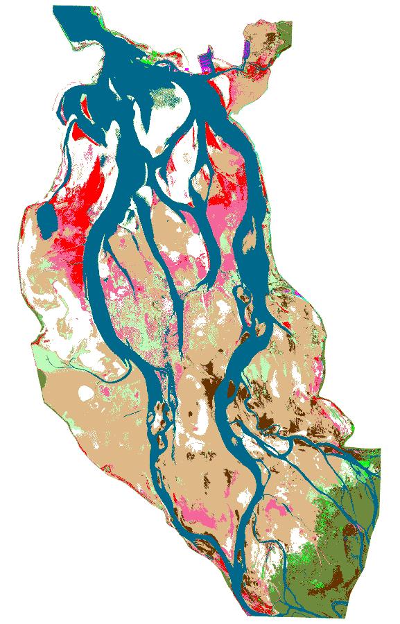
Eelgrass beds (composed largely of Zostera marina) were mostly concentrated in the northern 1/3 of the bay forming some extensive dense beds ( Figure 1: Eelgrass Map). Four of the five major rivers emptying into Tillamook Bay do so in the southern 1/3 where mud flats clearly dominated. The eelgrass beds that were mapped throughout this portion of the study area were mostly comprised of Zostera japonica. Although not seen at the rendered scale in Figure1, oyster culture activity could be detected in some areas from the presence of distinct parallel lines of bare substrate among eelgrass beds and in other cases, from rectangularly shaped beds.
Accuracy
The overall positional accuracy of the imagery compared to other ancillary data (road network from USGS 7.5′ quad) collected for the study area was determined to have an RMSE (Root Mean Square Error) of 18 m with the areas in the bay itself having closer to 5 m error and surrounding uplands having as high as a 40 m error. After numerous field visits, thematic accuracy has been estimated to be around 80%. Only a few locations comprising 5% of the overall area could not be classified without some manual interpretation due to clouds and haze. These areas were largely surrounded by extensive regions of water and mud. Vegetation was easier to differentiate than substrate types due to the confounding effects of moisture, however. Overall substrate classification was possible albeit coarser than what was hoped.
Discussion
This was the first time a bay-wide assessment was attempted using remote sensing. A previous transect-based analysis was performed looking at shellfish, eelgrass, and algae distributions in the mid 1970s (Hancock et al., 1979), and a similar approach was used to examine bay sediments by Avolio (1973). Using multispectral airborne imaging to perform these tasks shows great promise, however, a number of key issues must be addressed. To make the technology useful in change detection, improved accuracy must be accomplished and the seams between images must be cleaner. In addition, traditional color aerial photographs should be taken at the same time the multispectral imagery is collected adding finer texture information to the analysis. Also, additional band wavelengths would also improve the classification but should be pursued with caution in order to avoid excessively large data files (e.g. the full three band composite for this study was approximately 208 megabytes).
Results from this study will be combined with a tidal circulation model which has been developed in order to determine what effects, if any, water velocity and salinity regimes have on current eelgrass bed distributions. Also, by knowing the aerial extent of eelgrass beds, and to some degree sand, mud and rock, resource managers can better design biological inventories to sample within similar areas of the bay. For example, an ongoing benthic survey used the results from this study to randomly stratify benthic samples. The relationship between population densities of benthic organisms and substrate types can be used to develop predictive models that can be used to predict the effects of management actions such as dredging on benthic populations. When combined with oyster culture activity, monitoring eelgrass remotely provides a cost-effective means by which to understand and measure the interaction of oyster culture and eelgrass dynamics. Finally, the results from this study will serve as a baseline against which future natural or anthropogenic change can be assessed upon the eelgrasses of the Tillamook Bay estuary.
Approach
In mid July, 1995 multispectral imagery was collected (1 m resolution) using a light aircraft mounted with a prototype system called AirCam^TM developed by the Kestrel Corporation. Over 350 separate multispectral images were captured during the 4+ hour data collection period at maximum low tide. Three spectral bands were selected to mimic Landsat TM imagery bands 2 (blue), 4 (red) and 5 (near-infrared). The images were mosaicked and georeferenced before classification, but only 225 images were needed to map the bay and its immediate surroundings.
ERDAS ImagineTM 8.2 running on a Sun Sparc5 workstation was used to classify the imagery. The lengthy duration of data capture data
capture resulted in sun angle and atmospheric variation in the imagery making it necessary to classify each image separately. An iterative unsupervised classification technique was employed to differentiate a total of 12 classes. For each image a relatively small number of spectral classes were chosen to separate out water, bare substrate, and vegetation. Each image subset (water, substrate and vegetation) was then classified independently and later merged. Classified images were then recombined, edges smoothed manually if necessary, and clustered polygons resampled at 10 pixels. Several field visits were undertaken to assign and later refine the differentiated cover classes.