REPORT LINK
July 2001
Executive Summary
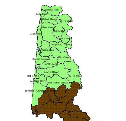
This project was conducted by Earth Design Consultants, Inc. and Green Point Consulting. We worked with the MidCoast Watershed Council (MCWC) to use existing information to analyze and prioritize 6th field watersheds in the Alsea, Salmon, Siletz, Yaquina, and coastal watersheds.

Approach
Task 1. Build core data layers.
Watershed assessments are a management tool. To guide recommendations and action plans, the tool must be constructed from data that accurately describe watershed conditions. Certain data layers are key to the process because they form the base on which other data and management decisions are built. Built from core data layers, the base map determines the degree of detail at which the analyses of watershed conditions can be performed. These core data include: Streams and other water bodies; Land cover (vegetation, bare ground, urban areas, etc.); Roads; Terrain (including stream gradients, channel confinement, and watershed morphometry); Fish abundance and distribution; In-stream conditions (for example, gravel, pools); Water quality; Land use (zoning); Soils; and Geology.
Building core data layers involves three specific tasks: (1) critical review of existing data, (2) identification of data gaps, and (3) development of new data.
Task 2. Develop comprehensive analyses of watershed conditions from core data.
Geographic information systems (GIS) data are spatially explicit and geographically referenced, and can be analyzed and manipulated in ways that are uniquely useful in understanding watersheds. The GIS-based analyses performed in this step is based on concepts and approaches in the current (1999) draft of the GWEB Watershed Assessment Manual. As with other steps, analyses performed are made only after thorough discussion with MCWC. Examples of these GIS analyses include: Length of source, transport, and deposition reaches by watershed, using DEM-generated streams layer; Length of confined and unconfined stream reaches by watershed, using DEM-generated streams layer ; Land cover versus fish presence/abundance; Debris flow/mass wasting risk areas (slope and slope morphometry versus soil type); Riparian cover versus fish presence/ abundance.
Task 3. Develop a list of recommendations and priority actions for the watersheds, along with rationale for the list.
Recommendations and priority actions are defensible, because they are based on analyses conducted using solid, critically-reviewed data. Along with the list of recommendations and priority actions, we expect to establish quantitative benchmarks for watershed parameters, which can be compared in the future to new values obtained through monitoring (Task 4).
Task 4. Make recommendations for future monitoring.
We believe that monitoring recommendations are a key part of any watershed assessment. Monitoring is vital to determine success of restoration efforts, to fill data gaps, and to keep existing data layers up-to-date. With well-planned monitoring, the MCWC’s understanding of the watershed will improve greatly over time. The Council will be able to document watershed changes and revise action plans accordingly. This process of “adaptive management” will maximize the chances of successful watershed management.
Task 5. Attend meetings of the MCWC and its technical advisory team, and maintain close communications with MCWC members.
Throughout this project, we have emphasized the importance of joint discussion between our team and the MCWC. Ongoing discussions will be used to guide central decisions in this watershed assessment. We will maintain close communication with the MCWC.
